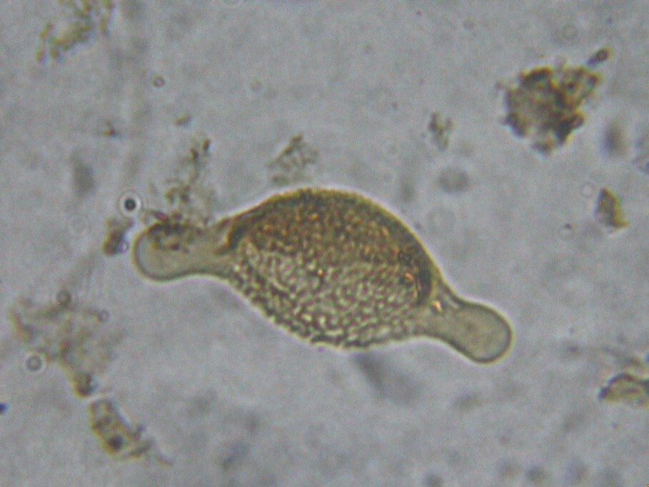
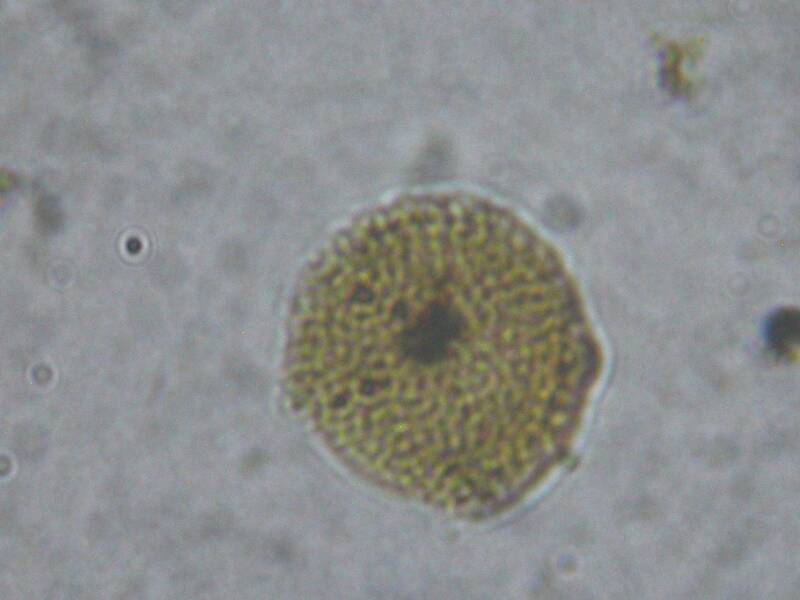
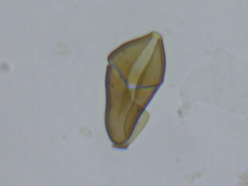
Palynological assemblage of the rocks of Lafarge Borehole 66, Ewekoro area Southwestern Nigeria.
A high resolution biostratigraphic study was carried out on twenty eight(28) core samples retrieved from well-66, ewekoro southwestern Nigeria. They were subjected to palynological analysis to determine their age, biozonation and paleoenvironment of deposition. The studied interval ranges from 0.00m-29.7m depth. A lithologic description of the core samples revealed that the bulk of the lithofacies constitutes limestone followed by Sandy limestone, clay and silty mudstone which are light brown, grey and dark grey in colour.
Three major palynological zones of verrucatosporites usmensis zone (paleocene and younger), Monocolpites marginatus Zone(Paleocene) and Echitricolpites trianguliformis zone(Maastrichitian) we're erected for this well based on the index taxa and palynological assemblage recorded. The age of the samples was therefore determined to be from Maastrichitian-Paleocen and Younger. Paleoenvirinment of the sediments of this study was determined to be shallow marine algal carbonate or mixed shallow marine clastic/carbonate environment based on Monocolpites Marginatus, Proxapertites cursus, verrucatosporites usmensis, constructi pollenite ineffectual, periretisyncolpitagenatus present.
Thesis Topic: MINERALOGICAL CHARACTERIZATION OF GOLD-BEARING ROCKS AROUND OKEMESI-IJERO AREA SOUTHWESTERN NIGERIA
The mineralogical characterization of the gold bearing rocks around Okemesi-Ijero, Southwestern Nigeria was carried out using Petrographic and X-ray diffraction (XRD) studies to determine the mineralogical phase of the gold showings. Various researchers have worked in the studied area most especially Ayodele et al., (2017), who carried out geochemical analysis (XRF) on the bedrocks, indicating showings of gold mineralization in Okemesi (Ajindo) with concentration values of 10-0.05ppm. This prompted the investigation for confirmation of gold mineralization on the bedrocks of Okemesi area (Ajindo). The method of investigation included systematic geologic mapping of the
various lithologies, sampling of the various lithologic units at a density of one sample per 100sqkm, followed by petrographic studies using light transmitting Petrological Microscope and mineralogical characterization of the various rocks using X-ray diffraction techniques (XRD). Twenty-six (26) rock samples were collected from the studied area, and were prepared for thin section using the standard procedures. However, seven (7) out of the samples majorly schistose and massive quartzites were selected and prepared for XRD analysis. The results of the petrographic studies revealed the dominance of the following minerals from four major rock types (schistose and massive
quartzites, granites and pegmatites) such that quartz has the highest percentage (62.29%), followed by the feldspars such as microcline (18.59%), plagioclase (6.89%), Orthoclase (0.82%), muscovite (15.71%), biotite (14.85%), opaque (3.47%), hornblende (1.12%),
and mymakite (0.36%). The X-ray diffractograms confirmed the presence of gold (Petrovskaite) in the Ajindo schistose quartzites. The schistose quartzites exhibited poor foliation which prevented the flow of auriferous hydrothermal fluid into the host rock.
Further studies can be carried out by using Micro X-ray Spectral Analysis to determine the concentration of the gold (petrovskaite) present in the host rock.


IDENTIFYING CRITICAL GROUNDWATER DISCHARGE LOCATIONS IN FLORIDA BAY, USA USING A GEOCHEMICAL TRACER AND INTERPOLATION MAPPING APPROACH
This study addresses the pressing need to understand groundwater discharge patterns in Florida Bay, a vital ecosystem currently threatened by environmental challenges like seagrass die-off. The research focuses on identifying key groundwater discharge zones within two basins of the bay, using radon as a natural geochemical tracer for submarine groundwater discharge. By applying advanced interpolation methods, the study generates detailed maps highlighting regions of significant radon concentrations, indicative of high groundwater discharge. The results aim to enhance knowledge of the bay's hydrological processes, providing critical insights for future conservation and resource management efforts in this ecologically sensitive area.
Photogrammetric Analysis of Displacements at a Control Retaining Wall
Course: CENG 5436 – Intro to Close-Range Photogrammetry
This study considered a Control Wall to test the ability of different 3D modeling techniques to capture undesirable displacements in mechanically stabilized earth (MSE) walls and modular walls. The main purpose of this work is to determine the minimum displacements that can be captured by the selected and studied approaches, which are based on terrestrial LiDAR and close-range photogrammetry. Models of the control wall were completed at two different times (epochs). The first epoch consisted of the original wall, without displacements. The second epoch captured the same wall but with artificially simulated displacements. This simulation was attained by attaching styrofoam tiles, with different thicknesses, on the wall. Thicknesses varied from 3 mm to 35 mm. 3D LiDAR models were generated using two techniques. One of them considered target-based registrations (stitching of scans) and the other employed visually aligned registrations. Photogrammetric models were generated by using two different schemes. One of them employed a hand-held camera whereas the other captured pictures with an unmanned aerial vehicle (UAV). Photo-based models were generated for the same control wall. They involved different numbers of pictures (~1080, ~540, and ~270). The larger the number of pictures, the more superpositions among them. Two software packages were used to produce the photogrammetry models, Agisoft’s Metashape and DroneDeploy. The more accurate results were obtained via the LiDAr models. However, Metashape models, via the hand-held camera, also were able to capture small displacements. The models generated by DroneDeploy, with the assistance of an UAV, were not accurate. However, one of the main causes of this inaccuracy is the fact that all employed ground control points were on a quasi horizontal surface, resembling a plane. When one control point is added at a certain elevation from that plane, accuracy improves. This was corroborated in a previous project, but was not able to be implemented in this study due to lack of time.


INVESTIGATING THE RELATIONSHIP BETWEEN SUBMARINE GROUNDWATER DISCHARGE AND SEAGRASS IN FLORIDA BAY, USA
Abstract
Florida Bay is a shallow, ecologically valuable estuary. It is comprised of a network of basins that are separated by extensive shallow mudbanks and mangrove islands. Seagrasses dominate the bay’s benthic habitat, forming mixed meadows and multistory canopies. Recurring hypersalinity, bottom-water anoxia, and long water residence times have triggered seagrass die-off. Although extensive research has been conducted on seagrasses in Florida Bay, any link between die-off or recovery and submarine groundwater discharge (SGD) remains insufficiently understood. This study uses radon-222 and continuous electrical resistivity profiling to identify SGD locations and explores its connection to the bay’s seagrasses. Preliminary findings suggest that SGD affects seagrass species differently, highlighting the need for targeted conservation strategies. These strategies could include locating SGD, identifying vulnerable seagrass species, pinpointing areas at risk for die-off, and understanding how SGD may influence seagrass die-off and recovery.
Comprehensive characterization of surface sediments in Clarks Hill Lake, Southeastern USA
Abstract
Comprehensive characterization of surface sediments in Clarks Hill Lake, Southeastern USA
Oluwatunmise Akanmu1, Aguinaldo Silva2, Jéssica Franzon Cruz Santo3, Edward L. Lo1,4
1School of Earth, Environment, and Sustainability, Georgia Southern University
2Faculty of Engineering, Federal University of Mato Grosso do Sul
3Faculty of Data Science, SENAI São Paulo
4Institute of Water and Health, Georgia Southern University
Sediment geochemistry plays a fundamental role in regulating nutrient availability, cycling organic matter, and moderating primary productivity in aquatic systems. The Clarks Hill Lake (J. Strom Thurmond Reservoir) is a temperate reservoir filled in 1952 along the Savannah River, which forms the Georgia–South Carolina state line. The reservoir experiences periodic algal blooms driven by excess nutrient inputs. Comprehensive characterization of surface sediments is therefore critical for understanding sedimentation patterns, nutrient enrichment, and their implications for reservoir productivity and management. In this study, lake floor sediment samples were collected using a Ponar grab sampler across spatial gradients in November 2025 and January 2026, capturing variations in hydrologyand sediment input Sediments were analyzed for elemental composition using energy-dispersive X-ray fluorescence (XRF), total organic carbon using infrared cell detection,and grain-size distribution using laser diffraction to quantify sediment texture and nutrient-related geochemical properties. By linking sediment geochemistry and grain-size distributions to hydrologic and depositional gradients, this study advances understanding of sediment dynamics and nutrient accumulation in a regulated temperate reservoir. This limnogeological study offers preliminary insight into the potential reuse of dredged nutrient-rich reservoir sediments to improve biomass production in nutrient-limited soils of the Southeastern United States.
